We've been home now for three days. In that time, we've relaxed, enjoyed our photos, thought about fixing up the boat, and tried to wrap our heads around finishing the trail. Mostly, we look at each other and know that we're thinking the same thing - wishing we were still paddling. Because, even on the NFCT's rainiest days, there were moments of sunshine...kindness from strangers, much needed tailwinds, wildlife sightings, mosquito free evenings, and so much more. We'll miss the trail, but are glad to have these wild, fun, tough, peaceful moments as storytelling material for years to come.
Disclaimer: You'll notice on our blog that we don't have many photographs from the "hard times" - Spencer Stream, rainy days, theft in NH, etc. During these moments we were far too preoccupied with our situation to pull out the camera. We don't want to romanticize the trail. It's not easy. It's hard. And thru paddling isn't for the faint of heart. That being said, we don't regret it and we highly recommend thru paddling to those with experience, commitment, and a stellar partner. Without each other, this experience would've been vastly different and, we think, much harder. If you're interested in thru paddling and want to hear our thoughts, feel free to contact us.
Many thanks to all the NFCT staff and volunteers for the signage, trails, and campsites you maintain. We enjoyed becoming part of the paddling community your organization fosters.
In case you haven't seen enough of our journey, check out the highlights video we created.
http://www.youtube.com/watch?v=v0guG99NtHY
Happy paddling,
Brian and Allie
Tuesday, July 30, 2013
Monday, July 29, 2013
NFCT Days 33-36
Day 33
We left Pillsbury Island early to beat the hoards of people at Chase Rapids. We had a nice paddle on Eagle Lake and arrived at the dam around 9. Just before the dam, we met George and Gary, two section paddlers who started at Moosehead Lake. We heard their horror stories of the mud pond carry and felt pleased with our decision to walk on the road. We loved talking with them about other sections that had paddled in previous years. This was the closest we'd come to meeting other thru paddlers and reminiscing was great!
Once at the dam, we met the ranger from the day before and completed our registration for the waterway. We bit the bullet and paid $10 to have our gear shuttled around Chase Rapids. The ranger suggested this would help us float better and even with the water release from the dam, it'd be a lot of rock dodging. So, we said goodbye to our gear and weaseled our way ahead of a large camp group. Once we started down the rapids, we understood why the ranger suggested shuttling the gear. Even with an empty boat, the rapids were rocky. We enjoyed the ride, though, and were done with the 4 mile stretch in about 45 minutes. We picked up our gear and headed towards Umsaskis Lake, where we were scheduled to meet up with Keith and Leslie. We made great time and were at the ranger station by 1 pm. We heard that many of the large camp groups were headed towards Umsaskis Lake/Long Lake for the evening, so we decided to snag a campsite early and get set up before heading back to the station to wait for Keith and Leslie. We picked Grey Brook on Long Lake, which is a beautiful site with a nice rocky beach and great morning sun. We had a snack, used the sun shower for the first time, and headed back to the ranger station with an empty boat. Right on schedule, Keith and Leslie showed up! Everything worked so smoothly and we enjoyed an evening paddle back to Grey Brook. Once there, we caught up, they tried out the boat, and we had a wonderful dinner.
26 miles


Day 34
We planned a big mileage day, but it seemed attainable because of the current on the Allagash. We headed out from Grey Brook around 7 and had an awesome, awesome day. The sun was shining, but the weather was dry and cool. We ate a relaxed lunch on Round Pond. We decided that if we came back someday, Round Pond would be a great place to camp or explore for an afternoon. Inlet and Turk Island are both choice sites. We continued down the Allagash to Ramsey Ledge campsite after exploring some old Lombard loghaulers. All around an amazing day.
30 miles


Day 35
Woke up to clouds and hoped the rain would hold. We made a quick stop at the Michaud Farm Ranger Station to register Keith and Leslie and sign out of the waterway. Before we knew it, we were at our last portage (WAHOO!) at Allagash Falls. We took our time here and enjoyed meeting Chip, a third generation Allagash guide. We admired his reflector oven, talked about poling, and scrambled up the rocks to admire Allagash Falls. Then we continued through the rapids and quick water. We were sad we didn't have any more moose sightings before leaving the Allagash waterway, but settled for some loons and plenty of bald eagles. Not a bad day for wildlife sightings!
Going through the town of Allagash was a bittersweet moment. Just around the bend, we'd be on our final river, the St. John. We felt so proud and excited about accomplishing such a tough trail, but knew the simplicity of our lives, the routine we'd created, and the quiet moments we loved would change when we pulled in to Fort Kent. Nevertheless, we had a trail to complete, so off we went! The rain still held off for us and we had a blast going through the wave trains and rapids on the St. John. We were lucky to have enough water to slide right over most of the shallow gravel bars. We camped for the night at Pelletiers. This is a wonderful site owned by Norman Pelletier with shade/rain structures, firewood, and a beautiful view of the river. For dinner we went to the Mooseshack where we warmed up with pizza and beer.
28 miles

Day 36 - The Final Day
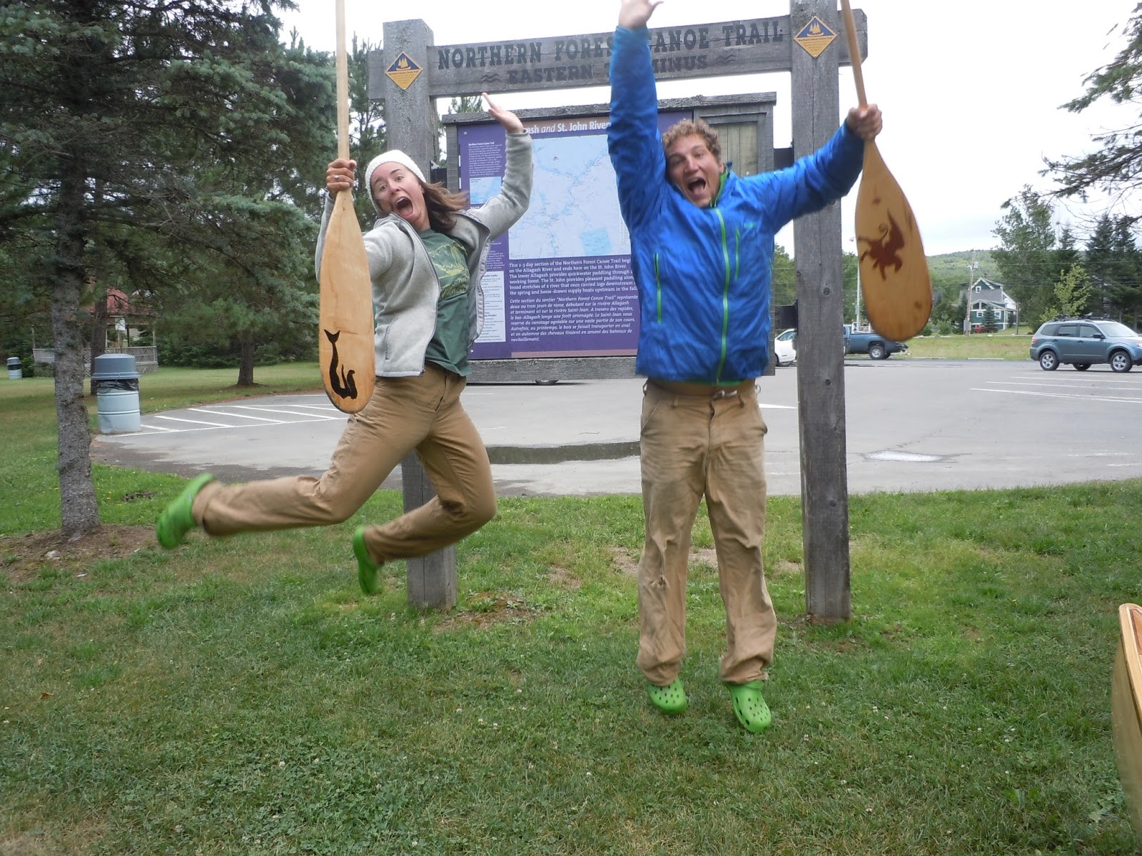
We woke up to another chilly, cloudy day, feeling a combination of sadness and excitement that in 17 miles, we'd be in Fort Kent. There was less swiftwater than the day before and we enjoyed the scenery and easy paddle. We took lots of photos and Leslie took some video as well. We arrived in Fort Kent around 10:45 am to a welcoming party made up of Keith, Leslie, Gary, and George. We popped a bottle of champagne to celebrate and belatedly christen our trusty canoe. We took the obligatory photographs at the NFCT Eastern Terminus Kiosk, signed the register, and tied up the canoes. It's hard knowing what to do when a trip that consumed every moment of your lives and thoughts for the past 50+ days comes to an end. So, we packed up and started the long haul back to NH, feeling both exhausted and proud of what we'd accomplished!


We left Pillsbury Island early to beat the hoards of people at Chase Rapids. We had a nice paddle on Eagle Lake and arrived at the dam around 9. Just before the dam, we met George and Gary, two section paddlers who started at Moosehead Lake. We heard their horror stories of the mud pond carry and felt pleased with our decision to walk on the road. We loved talking with them about other sections that had paddled in previous years. This was the closest we'd come to meeting other thru paddlers and reminiscing was great!
Once at the dam, we met the ranger from the day before and completed our registration for the waterway. We bit the bullet and paid $10 to have our gear shuttled around Chase Rapids. The ranger suggested this would help us float better and even with the water release from the dam, it'd be a lot of rock dodging. So, we said goodbye to our gear and weaseled our way ahead of a large camp group. Once we started down the rapids, we understood why the ranger suggested shuttling the gear. Even with an empty boat, the rapids were rocky. We enjoyed the ride, though, and were done with the 4 mile stretch in about 45 minutes. We picked up our gear and headed towards Umsaskis Lake, where we were scheduled to meet up with Keith and Leslie. We made great time and were at the ranger station by 1 pm. We heard that many of the large camp groups were headed towards Umsaskis Lake/Long Lake for the evening, so we decided to snag a campsite early and get set up before heading back to the station to wait for Keith and Leslie. We picked Grey Brook on Long Lake, which is a beautiful site with a nice rocky beach and great morning sun. We had a snack, used the sun shower for the first time, and headed back to the ranger station with an empty boat. Right on schedule, Keith and Leslie showed up! Everything worked so smoothly and we enjoyed an evening paddle back to Grey Brook. Once there, we caught up, they tried out the boat, and we had a wonderful dinner.
26 miles
 |
| Meeting up with Keith and Leslie on Umsaskis Lake |
 |
| Paddling back to camp |
 |
| Keith and Leslie trying out the boat |
 |
| Evening moose sighting |


Day 34
We planned a big mileage day, but it seemed attainable because of the current on the Allagash. We headed out from Grey Brook around 7 and had an awesome, awesome day. The sun was shining, but the weather was dry and cool. We ate a relaxed lunch on Round Pond. We decided that if we came back someday, Round Pond would be a great place to camp or explore for an afternoon. Inlet and Turk Island are both choice sites. We continued down the Allagash to Ramsey Ledge campsite after exploring some old Lombard loghaulers. All around an amazing day.
30 miles

 |
| Pumping water |

 |
| Lombard loghauler |
Woke up to clouds and hoped the rain would hold. We made a quick stop at the Michaud Farm Ranger Station to register Keith and Leslie and sign out of the waterway. Before we knew it, we were at our last portage (WAHOO!) at Allagash Falls. We took our time here and enjoyed meeting Chip, a third generation Allagash guide. We admired his reflector oven, talked about poling, and scrambled up the rocks to admire Allagash Falls. Then we continued through the rapids and quick water. We were sad we didn't have any more moose sightings before leaving the Allagash waterway, but settled for some loons and plenty of bald eagles. Not a bad day for wildlife sightings!
Going through the town of Allagash was a bittersweet moment. Just around the bend, we'd be on our final river, the St. John. We felt so proud and excited about accomplishing such a tough trail, but knew the simplicity of our lives, the routine we'd created, and the quiet moments we loved would change when we pulled in to Fort Kent. Nevertheless, we had a trail to complete, so off we went! The rain still held off for us and we had a blast going through the wave trains and rapids on the St. John. We were lucky to have enough water to slide right over most of the shallow gravel bars. We camped for the night at Pelletiers. This is a wonderful site owned by Norman Pelletier with shade/rain structures, firewood, and a beautiful view of the river. For dinner we went to the Mooseshack where we warmed up with pizza and beer.
28 miles

 | |
| The final portage! |
 |
| Quarriers minus Seth |
 |
| Allagash Falls |
 |
| Ready and excited for some class I-II rapids! |
 |
| Done with portages! Wahoo! |
 |
| Leslie makes a great escape |
 |
| Wading to Pelletiers |
 |
| Setting up camp for the last time |
 |
| Pelletier's campground |
 |
| Pizza and Moosellaneous! |
We woke up to another chilly, cloudy day, feeling a combination of sadness and excitement that in 17 miles, we'd be in Fort Kent. There was less swiftwater than the day before and we enjoyed the scenery and easy paddle. We took lots of photos and Leslie took some video as well. We arrived in Fort Kent around 10:45 am to a welcoming party made up of Keith, Leslie, Gary, and George. We popped a bottle of champagne to celebrate and belatedly christen our trusty canoe. We took the obligatory photographs at the NFCT Eastern Terminus Kiosk, signed the register, and tied up the canoes. It's hard knowing what to do when a trip that consumed every moment of your lives and thoughts for the past 50+ days comes to an end. So, we packed up and started the long haul back to NH, feeling both exhausted and proud of what we'd accomplished!
 |
| Loving the flowers George and Gary left in our boat! |
 |
| The bridge in Fort Kent, our last landmark before Riverside Park |
 |
| The last few paddle strokes |
 |
| We did it! |

 |
| With our new friends, George and Gary |

 |
| Signed the register. That's a wrap! |
NFCT: Days 28-32
Day 28
We left Jackman late in the day after showering, lounging, and doing our last load of laundry. We were nervous about the strong winds, but hit the water anyhow. We started in Big Wood Pond and were quickly on the Moose River. There was little current on the river, so we enjoyed a floating lunch and tailwind for the majority of our float. After the Moose River, we headed out to Long Pond. There was an extreme SW wind as soon as we rounded the corner onto Long Pond. We were shooting to camp at the Lower Narrows campsite on Long Pond and debated how to best battle the wind and waves. We headed towards the north shore of the pond and rode a tailwind to the shore. Here we again debated what to do. The wind was still whipping and dark clouds were forming. We saw the same Outward Bound group we had met a few days earlier slowly working their way around the pond. This gave us the confidence to try again. So, we headed back out on the pond and decided to take a gamble: rather than fight against the wind near the shore, we put on our PFDs and rode the tailwind in the middle of the pond. The waves were large and it was scary watching the waves crest and fall underneath the canoe. We focused on keeping the boat straight and eventually made it to camp. We hunkered down under the tarp and tent and prepared for a large storm. The wind picked up even more and the rain came, but the storm moved fast and by bedtime, it had passed.
11 miles
Day 29
We woke up and left camp by 7:15 in anticipation of a long portage on Demo Rd. Long Pond was calm this morning, but we were still anxious to get back on the Moose River. The rapids on the Moose were fun and we pulled out at the well marked portage just above the Demo Rd. bridge. The class III rapid that ran under the bridge looked too large for us and we decided the rapids below looked too boney. So, we put on the wheels and started walking. The portage was extremely well marked and we didn't even need the trail updates we wrote down from the NFCT website. We carried the last short bit through the woods and made our way to Brassua Lake. It was cloudy and calm on Brassua Lake. Once on the Moose River again, we resupplied right before Moosehead at a general store. Thankfully there were adequate supplies, as we were counting on this to be our last resupply. We enjoyed a break on the store's dock and then made our way to Moosehead. As our guidebook and map warned, the weather changed quickly. As we made our way to the campsites on Mt. Kineo, the wind and waves picked up. We fought against the chop and landed as soon as we could. Even though it was a Saturday night, we had no trouble finding a campsite on Mt. Kineo. We had an early dinner, washed the boat, and hoped the winds would drop off before morning.
20 miles
Day 30
Woke up early and tried to beat the winds on Moosehead. The calm morning we were accustomed to earlier in the trip seemed to have disappeared! The wind was strong and the air was cool and crisp. We made a quick first crossing and decided to reassess the wind situation when we were closer to Big Duck Cove. Here we could wait at a campsite until the winds died down if necessary.
After fighting the wind for 2 hours, we decided to break. We stopped at the first campsite in Big Duck Cove, hoping it would only be for an hour or two. The wind never died down and we were faced with a decision: if we go now and stay close to shore, we could still make it to the Penobscot and stay on schedule to finish the 27th and meet Keith and Leslie on the 24th. If not, we wait for the night and hope the wind is better tomorrow. The most recent weather report we had looked at called for strong winds the next day as well, so we went for it. By late afternoon, we had safely arrived at the Northeast Carry. We briefly stopped to have a cup of coffee and talk with Ed and Shirley Raymond, the sole residents of Northeast Carry, ME and owners of Raymonds Country Store. We then continued on our way, putting in at a buggy spot on the Penobscot. We felt so relaxed on this wide, slow river and stopped for the night at Thoreau's Island (a great site, awesome for large groups)
19.5 miles
Day 31
We were reluctant to leave our great campsite, but were excited about finally going to Chesuncook Lake. We had heard from our friend, Nate, that a stop to meet John at The Store for his homemade rootbeer, fudge, and stories about Chesuncook was a must. So after an easy float down the Penobscot, we headed onto Chesuncook Lake. It was a little windy, but we landed safely at Graveyard Point. From here we enjoyed a short walk through the historic town on our way to meet John. We enjoyed a visit with him and loved hearing about life in the little community. Oh, and the root beer and fudge were great!
After our stop, we continued our paddle on Chesuncook. We were hoping to stop at one of the two campsites on Umbazooksus Stream for the night. We stopped at the first site, but it appeared that campers had set up there for the summer. Preferring a more private site, we decided to investigate the second. When we arrived, we met Dave. We enjoyed chatting with Dave, a longtime Maine resident and guide in the area.
21 miles
Day 32
From Umbazooksus Stream, the NFCT route takes you through Mud Pond. Even though this portage is a famous one, we decided to forgo the muck and bugs. Guy Allen Road left from our campsite and would take us right to Chamberlain Lake. We reasoned that the 2 mile Mud Pond carry would actually be 6 miles once we went back for our second load of gear. A 6 mile, wheelable road portage would be the same length, but much easier and more enjoyable. The portage was easy and we only saw one logging truck the entire 3 hours. The rain was steady by this point. We signed in at the Chamberlain ranger station and hit the lake. Although we've had many rainy days, this was the first day it rained consistently and was cold. We only stopped briefly to eat lunch, trying to stay warm by jumping around while eating. We chose the short Lock Dam carry to Eagle Lake. After a few hours of paddling, we decided to stop at Pillsbury Island for the night. We were chilled and needed to warm up. We set up camp, enjoyed some afternoon coffee, and lazed around. By dinner, the rain had stopped. As we were beginning dinner, a ranger stopped by. He said we could pay for our nights on the Allagash Waterway at the dam. He also warned us that there were many groups, some as large as 40, who would be running Chase Rapids in the morning. He advised us to get there as early as possible and he'd help expedite the process for us. We were still far from the dam, so this meant an early start in the morning.
19 miles
We left Jackman late in the day after showering, lounging, and doing our last load of laundry. We were nervous about the strong winds, but hit the water anyhow. We started in Big Wood Pond and were quickly on the Moose River. There was little current on the river, so we enjoyed a floating lunch and tailwind for the majority of our float. After the Moose River, we headed out to Long Pond. There was an extreme SW wind as soon as we rounded the corner onto Long Pond. We were shooting to camp at the Lower Narrows campsite on Long Pond and debated how to best battle the wind and waves. We headed towards the north shore of the pond and rode a tailwind to the shore. Here we again debated what to do. The wind was still whipping and dark clouds were forming. We saw the same Outward Bound group we had met a few days earlier slowly working their way around the pond. This gave us the confidence to try again. So, we headed back out on the pond and decided to take a gamble: rather than fight against the wind near the shore, we put on our PFDs and rode the tailwind in the middle of the pond. The waves were large and it was scary watching the waves crest and fall underneath the canoe. We focused on keeping the boat straight and eventually made it to camp. We hunkered down under the tarp and tent and prepared for a large storm. The wind picked up even more and the rain came, but the storm moved fast and by bedtime, it had passed.
11 miles
Day 29
We woke up and left camp by 7:15 in anticipation of a long portage on Demo Rd. Long Pond was calm this morning, but we were still anxious to get back on the Moose River. The rapids on the Moose were fun and we pulled out at the well marked portage just above the Demo Rd. bridge. The class III rapid that ran under the bridge looked too large for us and we decided the rapids below looked too boney. So, we put on the wheels and started walking. The portage was extremely well marked and we didn't even need the trail updates we wrote down from the NFCT website. We carried the last short bit through the woods and made our way to Brassua Lake. It was cloudy and calm on Brassua Lake. Once on the Moose River again, we resupplied right before Moosehead at a general store. Thankfully there were adequate supplies, as we were counting on this to be our last resupply. We enjoyed a break on the store's dock and then made our way to Moosehead. As our guidebook and map warned, the weather changed quickly. As we made our way to the campsites on Mt. Kineo, the wind and waves picked up. We fought against the chop and landed as soon as we could. Even though it was a Saturday night, we had no trouble finding a campsite on Mt. Kineo. We had an early dinner, washed the boat, and hoped the winds would drop off before morning.
20 miles
 |
| A beautiful night on Mt. Kineo |
Woke up early and tried to beat the winds on Moosehead. The calm morning we were accustomed to earlier in the trip seemed to have disappeared! The wind was strong and the air was cool and crisp. We made a quick first crossing and decided to reassess the wind situation when we were closer to Big Duck Cove. Here we could wait at a campsite until the winds died down if necessary.
After fighting the wind for 2 hours, we decided to break. We stopped at the first campsite in Big Duck Cove, hoping it would only be for an hour or two. The wind never died down and we were faced with a decision: if we go now and stay close to shore, we could still make it to the Penobscot and stay on schedule to finish the 27th and meet Keith and Leslie on the 24th. If not, we wait for the night and hope the wind is better tomorrow. The most recent weather report we had looked at called for strong winds the next day as well, so we went for it. By late afternoon, we had safely arrived at the Northeast Carry. We briefly stopped to have a cup of coffee and talk with Ed and Shirley Raymond, the sole residents of Northeast Carry, ME and owners of Raymonds Country Store. We then continued on our way, putting in at a buggy spot on the Penobscot. We felt so relaxed on this wide, slow river and stopped for the night at Thoreau's Island (a great site, awesome for large groups)
19.5 miles
 |
| A chilly (and lazy) layover at Big Duck Cove |
 |
| View of Moosehead from the start of the Northeast Carry |
 |
| Best 99 cent purchase ever |
 |
| Northeast Carry, town of 2! |
 |
| Photoshoot on Thoreau Island |
Day 31
We were reluctant to leave our great campsite, but were excited about finally going to Chesuncook Lake. We had heard from our friend, Nate, that a stop to meet John at The Store for his homemade rootbeer, fudge, and stories about Chesuncook was a must. So after an easy float down the Penobscot, we headed onto Chesuncook Lake. It was a little windy, but we landed safely at Graveyard Point. From here we enjoyed a short walk through the historic town on our way to meet John. We enjoyed a visit with him and loved hearing about life in the little community. Oh, and the root beer and fudge were great!
After our stop, we continued our paddle on Chesuncook. We were hoping to stop at one of the two campsites on Umbazooksus Stream for the night. We stopped at the first site, but it appeared that campers had set up there for the summer. Preferring a more private site, we decided to investigate the second. When we arrived, we met Dave. We enjoyed chatting with Dave, a longtime Maine resident and guide in the area.
21 miles
 |
| Penobscot River |
 |
| Enjoying the sun |
 |
| And the Moose count grows! |
 |
| Canoe on Graveyard Point, Chesuncook Lake |
 |
| The Store, Chesuncook Lake |
 |
| Breathtaking views of Mt. Katahdin |
Day 32
From Umbazooksus Stream, the NFCT route takes you through Mud Pond. Even though this portage is a famous one, we decided to forgo the muck and bugs. Guy Allen Road left from our campsite and would take us right to Chamberlain Lake. We reasoned that the 2 mile Mud Pond carry would actually be 6 miles once we went back for our second load of gear. A 6 mile, wheelable road portage would be the same length, but much easier and more enjoyable. The portage was easy and we only saw one logging truck the entire 3 hours. The rain was steady by this point. We signed in at the Chamberlain ranger station and hit the lake. Although we've had many rainy days, this was the first day it rained consistently and was cold. We only stopped briefly to eat lunch, trying to stay warm by jumping around while eating. We chose the short Lock Dam carry to Eagle Lake. After a few hours of paddling, we decided to stop at Pillsbury Island for the night. We were chilled and needed to warm up. We set up camp, enjoyed some afternoon coffee, and lazed around. By dinner, the rain had stopped. As we were beginning dinner, a ranger stopped by. He said we could pay for our nights on the Allagash Waterway at the dam. He also warned us that there were many groups, some as large as 40, who would be running Chase Rapids in the morning. He advised us to get there as early as possible and he'd help expedite the process for us. We were still far from the dam, so this meant an early start in the morning.
19 miles
 |
| Found the Miller Time campsite on our portage |
Friday, July 19, 2013
NFCT: Days 24-27
End of day 24:
After we left Rangeley we paddled across Haley Pond and started our search for the portage trail to Route 16. After paddling the end of the lake we could find no trail. We took out at a private dock and hoped that no one would mind. Once on Route 16, we had a 4 mile walk to our campsite at the start of the S. Branch of the Dead River. The campsite was little more than a pull off on the side of the road. We fell asleep to the sounds of logging trucks speeding past us.
20 miles
Day 25:
We woke early to beat the traffic on Route 16. We decided it would be easiest to walk the road because of low water on the S. Branch of the Dead. Within the first 5 minutes it was VERY clear that walking 14 miles was not a safe option. Logging trucks seemed exempt from following the speed limit. Also, no shoulder. We decided that we had better try paddling. We got on the S. Branch and began paddling. At first it seemed like the right choice. But around a few bends the water disappeared and many fallen logs crossed our path. We decided this route was no better. We turned around and paddled back upstream to our starting point. We did the thing we were dreading. We called the local outfitters, Ecopelagicon. They graciously came and picked us up. We felt weird skipping a section of the trail, but felt that our safety, along with the boat's, would have been at risk if we had chosen either route. We were dropped off at Flagstaff Lake where we enjoyed a beautiful paddle. We had this gigantic lake all to ourselves, as usual. Though we frequently wonder why folks aren't outdoors at the peak of the summer, we didn't complain too much. We passed islands, calling loons, and the flooded village of Flagstaff. Around one corner a bull moose was spotted eating. We floated by watching him, reveling in our first moose spotting! We camped at the far end of the lake on an island just before the dam. Around dinner time we heard beating wings out on the lake. We went out on the point to investigate. It appeared to be two loons fighting. They locked beaks and hit each other with their wings. What a wild sight! After some internet investigation, we learned that loons are quite territorial and sometimes fight to the death over territory.
20 miles paddled and 19 miles skipped
Day 26:
We started the day with a short portage around Flagstaff dam and put in at the Big Eddy campsite. Once on the Dead River the paddling was easy. We soon reached the Grand Falls carry and took out at the high water portage trail. There was no sign for this portage, but we saw rapids downstream and decided to investigate. Once in the woods, the signage improved. However, trail is a strong word for the bushwack that followed! We carried the first portion and on our way back to retrieve more gear, we found a ground nest of bees. After making a mad dash away from them and feeling sorry for our stings, we continued our bushwack. Eventually we hit a dirt track where we could wheel the rest of the way. It appeared to be a trail maintained by the Maine Huts and Trails. We hiked back up to the falls and ate lunch. Though the portage was tough, the sight of Grand Falls was worth it! Reluctantly, we buckled up for our last upstream section, Spencer Stream. The stream was easy to find but going did not look good. We scouted for the dirt track that was marked on the map to no avail. Upstream was our only option here. We started around noon and hoped to finish the 7 miles of Spencer Stream by late evening. We soon realized that this wasn't happening. The going was slow. There wasn't enough water to paddle upstream, so we dragged the boat upstream, careful not to slip on the rocks. Occasionally we could paddle 3 or 4 strokes, but they would then be followed by another shallow section. We were beat and in low spirits. We finally made it to Little Spencer Stream in just under 3 hours. We dragged the boat until 5:30 when we could go no further. We found a somewhat flat piece of ground and set up the tent. Soon the thunderstorm and rain found us, which brought spirits to an all time low. With a soggy tent we fell asleep.
11 miles
Day 27:
Man was it was hard to start the day. Spirits were still low, our gear was soggy, and we weren't 100% positive we were even on the correct stream. Two hours in we came to the dead waters...what a relief! This marked the end of our upstream paddling and confirmed that we were in fact in the right place. With no official portage trail around the dam, we improvised by dragging the canoe over a steep rock ledge. Once the gear and canoe were in the water and we paddled around the dam booms, we felt the greatest sense of accomplishment and relief. The upstream was done! Our mood did a 360 and we again felt that anything was possible. We set a goal for Jackman to splurge on a Motel one last time. We flew across the lakes, walked the 4 mile portage and were excited to put into the Moose River. The scenery was amazing and before we knew it we were pulling into Jackman at 7 pm. Beer and pizza never tasted so good.
28 miles
200 miles left and the end date should be the 27th. We're looking forward to what Maine has in store for us.
After we left Rangeley we paddled across Haley Pond and started our search for the portage trail to Route 16. After paddling the end of the lake we could find no trail. We took out at a private dock and hoped that no one would mind. Once on Route 16, we had a 4 mile walk to our campsite at the start of the S. Branch of the Dead River. The campsite was little more than a pull off on the side of the road. We fell asleep to the sounds of logging trucks speeding past us.
20 miles
Day 25:
We woke early to beat the traffic on Route 16. We decided it would be easiest to walk the road because of low water on the S. Branch of the Dead. Within the first 5 minutes it was VERY clear that walking 14 miles was not a safe option. Logging trucks seemed exempt from following the speed limit. Also, no shoulder. We decided that we had better try paddling. We got on the S. Branch and began paddling. At first it seemed like the right choice. But around a few bends the water disappeared and many fallen logs crossed our path. We decided this route was no better. We turned around and paddled back upstream to our starting point. We did the thing we were dreading. We called the local outfitters, Ecopelagicon. They graciously came and picked us up. We felt weird skipping a section of the trail, but felt that our safety, along with the boat's, would have been at risk if we had chosen either route. We were dropped off at Flagstaff Lake where we enjoyed a beautiful paddle. We had this gigantic lake all to ourselves, as usual. Though we frequently wonder why folks aren't outdoors at the peak of the summer, we didn't complain too much. We passed islands, calling loons, and the flooded village of Flagstaff. Around one corner a bull moose was spotted eating. We floated by watching him, reveling in our first moose spotting! We camped at the far end of the lake on an island just before the dam. Around dinner time we heard beating wings out on the lake. We went out on the point to investigate. It appeared to be two loons fighting. They locked beaks and hit each other with their wings. What a wild sight! After some internet investigation, we learned that loons are quite territorial and sometimes fight to the death over territory.
20 miles paddled and 19 miles skipped
 | ||||
| Some of the obstacles on the S. Branch of the Dead River |
 |
| Swatting flies and feeling sorry for ourselves |
 |
| Bull grazes in Flagstaff Lake |
 |
| A primo campsite on Flagstaff |
Day 26:
We started the day with a short portage around Flagstaff dam and put in at the Big Eddy campsite. Once on the Dead River the paddling was easy. We soon reached the Grand Falls carry and took out at the high water portage trail. There was no sign for this portage, but we saw rapids downstream and decided to investigate. Once in the woods, the signage improved. However, trail is a strong word for the bushwack that followed! We carried the first portion and on our way back to retrieve more gear, we found a ground nest of bees. After making a mad dash away from them and feeling sorry for our stings, we continued our bushwack. Eventually we hit a dirt track where we could wheel the rest of the way. It appeared to be a trail maintained by the Maine Huts and Trails. We hiked back up to the falls and ate lunch. Though the portage was tough, the sight of Grand Falls was worth it! Reluctantly, we buckled up for our last upstream section, Spencer Stream. The stream was easy to find but going did not look good. We scouted for the dirt track that was marked on the map to no avail. Upstream was our only option here. We started around noon and hoped to finish the 7 miles of Spencer Stream by late evening. We soon realized that this wasn't happening. The going was slow. There wasn't enough water to paddle upstream, so we dragged the boat upstream, careful not to slip on the rocks. Occasionally we could paddle 3 or 4 strokes, but they would then be followed by another shallow section. We were beat and in low spirits. We finally made it to Little Spencer Stream in just under 3 hours. We dragged the boat until 5:30 when we could go no further. We found a somewhat flat piece of ground and set up the tent. Soon the thunderstorm and rain found us, which brought spirits to an all time low. With a soggy tent we fell asleep.
11 miles
 |
| Grand Falls, Dead River |
Day 27:
Man was it was hard to start the day. Spirits were still low, our gear was soggy, and we weren't 100% positive we were even on the correct stream. Two hours in we came to the dead waters...what a relief! This marked the end of our upstream paddling and confirmed that we were in fact in the right place. With no official portage trail around the dam, we improvised by dragging the canoe over a steep rock ledge. Once the gear and canoe were in the water and we paddled around the dam booms, we felt the greatest sense of accomplishment and relief. The upstream was done! Our mood did a 360 and we again felt that anything was possible. We set a goal for Jackman to splurge on a Motel one last time. We flew across the lakes, walked the 4 mile portage and were excited to put into the Moose River. The scenery was amazing and before we knew it we were pulling into Jackman at 7 pm. Beer and pizza never tasted so good.
28 miles
 |
| Our combo hotel/taxidermist. Yep. |
 |
| Done with upstream and loving life! |
200 miles left and the end date should be the 27th. We're looking forward to what Maine has in store for us.
Subscribe to:
Posts (Atom)